The United Nations General Assembly has overwhelmingly voted to adopt an African-led resolution calling for a global transition away from the centuries-old Mercator projection.
Designated as resolution A/80/L.104 and introduced by Togo on behalf of the African Group, the measure passed with 164 votes in favor. The initiative promotes the adoption of equal-area map projections, specifically highlighting the Equal Earth map, to accurately represent the true proportions of the world’s landmasses.
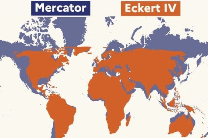
For nearly five centuries, the global standard has been dominated by the Mercator projection, created in 1569 by Flemish cartographer Gerardus Mercator. While practical for maritime navigation in an era of European exploration, the projection severely distorts the size of landmasses based on their latitude. Regions near the poles are dramatically enlarged, while equatorial and tropical areas are significantly shrunken. Most notably, Africa appears roughly the same size as Greenland on a standard Mercator map, despite Africa actually being approximately 14 times larger in reality.
Advocates for the new resolution argue that these distortions are far from harmless cartographic quirks. Proponents maintain that visual bias feeds subconscious perceptions about global importance, resources, and power dynamics.
“A fair world begins with a fair map,” Togo’s Foreign Minister Robert Dussey told the General Assembly during arguments for the measure. He framed the resolution as a matter of “cognitive justice, with access to precise geographical knowledge, the dignity of peoples, historic memory,” while explicitly linking the widespread use of the Mercator map to the enduring legacies of colonization.
African leaders have emphasized that the distorted maps minimize the perceived sizes, socio-economic realities, infrastructure needs, and development potential of regions across the Global South, including Africa, Latin America, and South Asia.
The lopsided vote marks a substantial diplomatic triumph for the African continent, arriving amid a broader wave of multilateral engagement and leadership. Somalia, which currently holds a non-permanent seat on the UN Security Council for the 2025–2026 term and recently served a historic stint holding the Council’s rotating presidency, joined the overwhelming majority in backing the resolution. African Union officials noted that the push for geographical accuracy reflects a continent insisting on being recognized at its true scale—geographically, economically, historically, and diplomatically.
The resolution also found support among several Western nations, with France announcing it would abandon the Mercator projection in official capacities. French Foreign Minister Jean-Noël Barrot stated ahead of the vote that “the time has come to correct them.”
Despite the broad international consensus, the initiative faced lone resistance and selective hesitation. The United States cast the sole opposing vote. US Ambassador to the UN Mike Waltz criticized the resolution, dismissing it not as a neutral cartographic correction, but as part of a larger “radical ideological project.” Waltz argued that the debate served as a distraction from pressing international security and prosperity issues, calling such measures “barnacles on our work here.”
Meanwhile, six nations abstained from the vote, including Ukraine, Estonia, Georgia, Lithuania, Moldova, and Serbia. Ukraine’s UN envoy, Andriy Melnyk, explained that his country withheld its vote because the Equal Earth projection depicted temporarily occupied Ukrainian territories in a manner deemed unacceptable by Kyiv.
While the UN vote establishes a powerful normative standard, the ultimate success of the “Correct the Map” campaign will hinge on practical implementation outside diplomatic chambers. Translating the resolution into real-world change will require widespread adoption by national school systems, textbook publishers, international organizations, and major digital mapping platforms like Google Maps. Togo has already signaled its intent to revise its own domestic textbooks as a test case, paving the way to see whether a symbolic vote in New York can successfully reshape how humanity pictures the world in classrooms everywhere.